Clark’s MILL, North River Road, Coventry
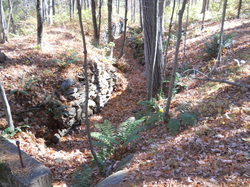
 Tail race below the foundation remnants.
Waterway: Skungamaug River
Water Power: Standard Wheel, type unknown
Mill type: Grist, saw, shingle, and planning mill.
Also a carpenter shop
Location: Latitude 41 49 22 N and
Longitude 71 21 05 W
Water Power: Standard Wheel, type unknown
Mill type: Grist, saw, shingle, and planning mill.
Also a carpenter shop
Location: Latitude 41 49 22 N and
Longitude 71 21 05 W
History – Clark’s Mill was an early mill constructed in the late 1700s and operated into the 1870s. It was a rather intricate site supporting a grist mill, saw mill, shingle mill, carpenter shop, and planning mill. The grist mill was converted to a spool factory. The saw mill remained active until about 1869 when use of the site declined rapidly.
Site Characteristics: The mill was a large site loated on the east side of North River Road and south of Folly Lane Remnants remaining include a dam and dam site, the mill site, and tail races.
Picture shows foundations along the embankment. Other remnants noted are the head race and tail race.
Additional Sources of Information: A History of Industry Along the Willimantic, Hop, and Skungamaug Rivers in Coventry, CT," by Bill Jobbagy, December 2004.
