Undocumented Mill Site on Roaring Brook, Village Hill Road/Route 32
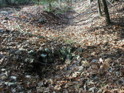
 Turbine pit and tail race located below the remnants of an old dam.
Waterway: Roaring Brook Water power: Turbine
Mill type: Unconfirmed
History – Downstream from the Eldredge Mills Archaeological District, in the vicinity of Route 32 (River Road), is another location that shows evidence of mill activity. It is located on a 19.8 acre parcel of land owned by the State of Connecticut.
Historical maps and documents depicted possible mill activity in this general location. Conflicting historical references locate mill activity both easterly and westerly of the current location of Route 32 along Roaring Brook. Town records for 1732 granted permission for Mr. Hinckley to set up a mill in the Willimantic River. He had owned land at the mouth of Roaring Brook running east in the vicinity of Route 32. The 1860 Clark and Tack bury map of Willington shows a “Gaines grist and saw mill.” This was most likely at the Eldredge mill site as in 1856. Nathan Mathews, one of the owners of Eldredge mill site, transferred a grist mill, saw mill, shingle mill and two shops to William Gains. Could there have been another mill near the Willimantic? Confirmation could not be made from historical documents.
Site Characteristics: Site inspections did not reveal any discernible evidence of a mill or water power activity westerly of Route 32. Close inspection of the State owned land downstream from Eldredge Mills showed signs of additional mill activity, including a number of sluiceways. Along the eastern boundary of the State site are the remnants of what appeared to be an old dam. Just below the remnants is a 40 inch turbine pit followed by a tail race.
Additional Sources of Information: Upcoming book on Willington’s Lost Mill Sites
