Unnamed Mill Site on Conant Brook, Ruby Road
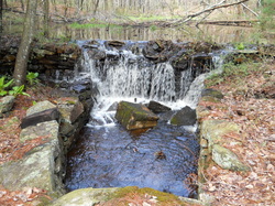 Dam, wheel pit, tail race, and mill site.
Waterway: Conant Brook Water power: Turbine or Standard Wheel
Mill type: Unconfirmed – Possibly a saw and grist mill
History – Unnamed Mill off Ruby Road - In the upper reaches of Conant Brook is a small old mill site. Little history could be found on the site, but undocumented reports indicated it was a saw mill and possibly a grist mill and electric generating facility.
Site Characteristics: Site A 90 foot dam about five to six feet high supported a 9,000 square foot pond creating about a seven to eight foot head for power. This upland site has a surprising amount of water flow due to the numerous ponds supported by number of springs in a small upstream watershed.
The dam is typical of the construction techniques from the late 1700s to the early 1800s. The pond is heavily silted as well. Below the dam are the remnants of two small buildings on each side of the spillway and race, or perhaps one mill building extending across the race. The spillway and race are located in the center of the dam. With limited head, the site could have supported an undershot wheel, but additional evidence raised questions as to whether a small turbine was used. A six inch pipe under the dam may have directed water to a wheel pit possibly containing a small turbine. The site may have supported a saw and grist mill with later use for electric power.
Additional Sources of Information: Upcoming book on Willington’s Lost Mill Sites
